Dry but cooler weekend
Updated: 5:59 AM EDT Apr 20, 2024
ACTION SPORTS 547 TIME NOW FOR PITTSBURGH’S ACTION WEATHER. THE PAST COUPLE OF WEEKENDS WE’VE BEEN TALKING ABOUT RAIN, RAIN AND MORE RAIN. FINALLY THAT CHANGES RIGHT? THIS WEEKEND, COMPLETELY DRY. IN FACT, WE COULD STRING TOGETHER THREE PLUS DAYS WITH NO RAIN. LOVE TO HEAR THAT, RIGHT? ESPECIALLY WITH THE WAY THINGS HAVE BEEN GOING AS WE LOOK OUT NOW OVER DOWNTOWN PITTSBURGH WITH ACTION CAM, YOU CAN SEE JUST A LITTLE BREAK IN THE CLOUD COVER THIS MORNING TO SEE THE START OF OUR SUNRISE, AND THERE WILL BE MORE SUNSHINE TO COME AS WE WORK THROUGH THE DAY. JUST DEALING WITH THE CLOUDS THAT OF COURSE BUILT IN YESTERDAY DAY BEHIND THOSE SHOWERS THAT WE HAD IN THE MORNING. NOT MUCH MAKING IT TO THE GROUND WITH SOME OF THOSE LIGHT RETURNS ON THE RADAR AS WE GET CLOSER TO I 80 AS REALLY WE’RE JUST IN THE MIDST OF A AIR MASS CHANGE, IF YOU WILL. IF YOU ARE HEADING TO PNC PARK MIDDLE GAME OF THE SERIES WITH THE RED SOX, IT IS GOING TO BE A LITTLE BIT COOL BREEZY FOR US. WE GO THROUGH THE AFTERNOON, OF COURSE, FIRST PITCH IS AT 405. MIX OF SUNSHINE AND CLOUDS. CERTAINLY FEELING LIKE AN APRIL DAY HERE IN PITTSBURGH. TEMPERATURES WILL ONLY BE RUNNING IN THE MID TO UPPER 50S FOR A HIGH, AND WITH THE WIND COMING IN TOO, OF COURSE CAN MAKE IT FEEL JUST A LITTLE BIT COOLER OUT THERE AT PNC PARK AND ACROSS THE REGION TODAY. AS WE WORK INTO THE AFTERNOON, YOU WILL NOTICE THOSE CLOUDS BREAK, REVEALING MORE SUNSHINE. CLOUDS WILL TRY AND BUILD BACK IN AS WE LOOK TOWARDS DAYBREAK TOMORROW. THAT WOULD ACTUALLY HELP US OUT GIVEN THE COOL AIR MASS THAT IS IN PLACE. TEMPERATURES MAY NOT STEEPLY DROP AS FAST AS THEY WOULD IF SKIES WERE CLEAR, BUT STILL, THERE IS A FROST POTENTIAL AREA WISE, WE ARE EXPECTING THOSE LOWS TO BE STARTING TOMORROW IN THE 30S. BY THE AFTERNOON THOUGH, RETURNING TO THE MID 50S WITH A MIX OF SUNSHINE AND CLOUDS FOR YOUR SUNDAY. AND THEN GET THIS STILL DRY INTO MONDAY WON’T BE UNTIL THE AFTERNOON. EVEN THE EVENING HOURS TUESDAY THAT WE START TO SEE THE RETURN OF SOME SHOWER CHANCES. TEMPERATURES RIGHT NOW COOLER TO THE NORTH, JUST 45 IN CLARION, 50 HERE IN PITTSBURGH. ALSO FOR GREENSBURG. UNIONTOWN 52, MORGANTOWN 49. AS YOU GET YOUR DAY STARTED IN WASHINGTON AS WE GO INTO THE AFTERNOON, NOT MUCH OF A BUILD, ESPECIALLY WITH THAT BREEZE COMING IN OUT OF THE NORTHWEST. COULD BE GUSTING UP TO 30MPH. OVERALL, A MIX OF SUNSHINE AND CLOUDS. 56 IS OUR FORECAST HIGH. NORMAL IS 65 FOR THIS LATE STAGE IN APRIL. THEN TONIGHT THE WINDS GOING TO DIE DOWN. CLOUDS WILL BE THE QUESTION MARK AS TO WHICH SPOTS SEE SOME FROST OR EVEN SOME FREEZING TEMPERATURES. TONIGHT ON FORECASTING 36 IN PITTSBURGH, THE AREA. WHY THERE IS A FREEZE WATCH WILL TAKE US THROUGH SUNRISE EVEN BEYOND ON SUNDAY, SO WE’LL CERTAINLY HAVE TO KEEP AN EYE OUT FOR SOME OF THOSE TENDER PLANTS AS THE GROWING SEASON HAS JUST STARTED AREA WIDE HERE IN WESTERN PENNSYLVANIA, THERE COULD BE ANOTHER FROSTY START TO YOUR MONDAY TEMPERATURES AGAIN BACKING OFF INTO THE MID 30S. BY THE AFTERNOON, THOUGH, THE RETURN OF THE 60S WILL STAY PUT IN THE 60S FOR HIGHS, MOST OF NEXT WEEK. HERE COMES SOME SHOWERS SHOWING UP LATE IN THE DAY ON TUESDAY THAT WILL SPILL OVER INTO WEDNESDAY AND MORE THAN LIKELY WE WILL GET ENOUGH TO TIE POSSIBLY EVEN BREAK THE RECORD FOR THE WETTEST APRIL EVER HERE IN THE CITY OF PITTSBURGH. BUT MORE DRY TIME THAN NOT IN YOUR 4-DAY PLUS 4 MORE FORECA
Dry but cooler weekend
Updated: 5:59 AM EDT Apr 20, 2024
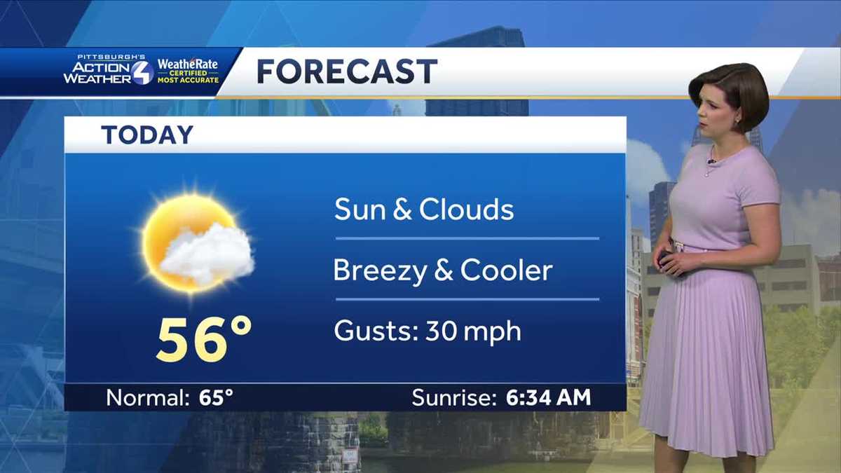
Finally, a dry weekend! This is the beginning of a dry stretch that will extend into Tuesday morning. High pressure is in control, but it is pulling in a seasonably cool air mass. Highs this weekend will run 10 degrees below normal. Today will also be a tad breezy with 25-30 mph gusts. A Freeze Watch is in place for the entire area tonight, but clouds could limit how low temperatures drop. More clouds = less cooling. Monday morning could be frosty in spots too. Temperatures trend closer to normal next week. Showers return Tuesday afternoon. We only need 0.26″ to tie the wettest April in Pittsburgh.TODAY: Sun and clouds, breezy and cooler. High 56°, gusts up to 30 mph.TONIGHT: Wind diminishes, increasing clouds late. Freeze Watch, low 36°.TOMORROW: Partly cloudy and seasonably cool, high 55°.
Finally, a dry weekend! This is the beginning of a dry stretch that will extend into Tuesday morning. High pressure is in control, but it is pulling in a seasonably cool air mass. Highs this weekend will run 10 degrees below normal. Today will also be a tad breezy with 25-30 mph gusts. A Freeze Watch is in place for the entire area tonight, but clouds could limit how low temperatures drop. More clouds = less cooling. Monday morning could be frosty in spots too. Temperatures trend closer to normal next week. Showers return Tuesday afternoon. We only need 0.26″ to tie the wettest April in Pittsburgh.
TODAY: Sun and clouds, breezy and cooler. High 56°, gusts up to 30 mph.
TONIGHT: Wind diminishes, increasing clouds late. Freeze Watch, low 36°.
TOMORROW: Partly cloudy and seasonably cool, high 55°.
Source
#Dry #cooler #weekend