Impact Day Monday with periods of rain
Impact Day Monday with periods of rain
Updated: 7:04 PM EDT Mar 31, 2024
SO SOMETHING YOU WANT TO BE MINDFUL OF AS WE HEAD INTO THE NEW WEEK. CLOUDS OVERHEAD ON ACTION CAM, WE HAVE SEEN SOME THINNING TO ALLOW A LITTLE BIT OF SUNSHINE THROUGH TODAY, BUT STILL NOT BAD FOR OUR EASTER SUNDAY. 58 IS THE CURRENT TEMPERATURE AT THE AIRPORT. OUR HIGH TODAY WAS 59. WINDS ARE FROM THE NORTH AT SEVEN MILES PER HOUR, AND WE’LL KIND OF SHIFT WINDS AROUND TO THE SOUTHEAST THROUGH THE NIGHT AND INTO TOMORROW AS WE WATCH FOR RAIN SHOWERS ARRIVING OVERNIGHT. RAIN WILL BE HEAVY THROUGH THE MORNING COMMUTE, AND THEN RAIN LOOKS TO PICK RIGHT BACK UP TOWARDS THE END OF THE EVENING COMMUTE AND LAST INTO YOUR TUESDAY MORNING AS WELL. SEVERAL ROUNDS OF RAIN ARE COMING FOR NOW. JUST THE CLOUDS THOUGH. THAT’S THE GOOD NEWS. IF YOU’RE HEADING OUT THIS EVENING, YOU’RE FINE. ANY OUTDOOR PLANS? YOU’RE GOOD TO GO. STARTING ABOUT TWO 3:00 IN THE MORNING, RAIN SHOWERS BEGIN, ARRIVING AGAIN. RAIN IS WITH US FOR THE MORNING COMMUTE AND COULD BE HEAVY AT TIMES. RAIN SHOULD TAPER OFF FROM THIS FIRST ROUND ABOUT 10:00 OR SO. WE’RE THEN DRIVE THROUGH THE AFTERNOON, SO IF YOU’RE HEADING OUT TOMORROW, TRY AND LEAVE ABOUT 11 OR NOON. IF YOU CAN, UNTIL ABOUT SIX 7:00. YOU’LL BE OKAY. THEN. RAIN SHOWERS RETURN FOR US THROUGH MONDAY EVENING INTO YOUR TUESDAY MORNING. RAIN WILL THEN TAPER OFF A BIT ON TUESDAY WITH SCATTERED SHOWERS AROUND AND THEN WE’LL WATCH LATE IN THE DAY FOR THE POSSIBILITY OF SOME STRONGER THUNDERSTORMS AS A COLD FRONT GETS HERE, AND THEN WE’LL START TAPERING OFF THE RAIN AS WE HEAD INTO THE BACK PART OF TUESDAY INTO WEDNESDAY. BY THE TIME THE RAIN IS DONE INTO WEDNESDAY, WE’RE LOOKING GENERALLY WIDESPREAD 1 TO 3IN, WITH SOME LOCALLY HIGHER AMOUNTS. BECAUSE OF THAT, A FLOOD WATCH IS IN EFFECT FOR FAYETTE AS WELL AS GREENE COUNTIES IN PENNSYLVANIA AND MONONGALIA, PRESTON COUNTIES IN WEST VIRGINIA AND GARRETT COUNTY, MARYLAND UP TO FIVE INCHES POSSIBLE IN SOME LOCALIZED SPOTS. THIS STARTS AT 2:00 TONIGHT, SO 48 OUT THE DOOR TOMORROW MORNING. IMPACT DAY RAIN SHOWERS. WE COULD SEE UP TO AN INCH OF RAIN BY THE TIME IT TAPERS OFF TOMORROW MORNING. THEN RAIN RETURNS TOMORROW EVENING WITH AN ISOLATED THUNDERSTORM AT 6265 ON TUESDAY, 60 ON WEDNESDAY WITH SCATTERED SHOWERS AND TEMPERATURES FALL BY WEDNESDAY. THE OHIO RIVER IS EXPECTED TO CREST AT 19FT. THAT WOULD FLOOD THE MON WHARF. WE’LL START DRYING OUT ON THURSDAY. WE’RE DRY FOR THE PIRATES HOME OPEN
Impact Day Monday with periods of rain
Impact Day Monday with periods of rain
Updated: 7:04 PM EDT Mar 31, 2024
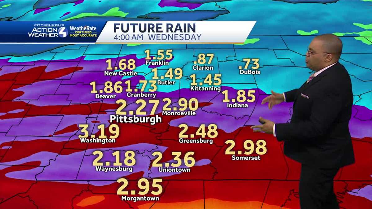
Our mild Easter will end with rain showers arriving overnight. Rain looks to overspread the area around 2-4am and last through the morning commute. Potentially up to one inch of rain is possible in this first wave. This, and a second round of rain later on Monday, will prompt an Impact Day for Monday. Localized flooding is possible Monday morning. Heavier rain and storms look to arrive Monday night into Tuesday, with periods of rain through the day on Tuesday. A line of storms looks to arrive Tuesday evening with the cold front. The rain and storms prompt an Impact Day for Tuesday. If storms can develop, damaging wind and hail are our primary concerns.All told, about 1-3″ of rain areawide is likely with localized amounts of up to 5″ in locations that see storms/heavy rain repeatedly move over the same areas. Small stream and creek flooding is possible at any point these two days, and especially into Wednesday as all of this water needs to go somewhere. A Flood Watch is up for PA/WV border counties where this is most likely. The Ohio River at Pittsburgh is expected to reach 18′ (flooding the Mon Wharf) Wednesday morning.Scattered showers/flurries will be possible Wednesday and Thursday as colder air filters into the region. We will dry out in time for the Pirates home opener and through the weekend. Eclipse viewing on Monday looks good for April with partly cloudy skies currently expected.Tonight: Impact Day. Rain showers. Low of 48.Tomorrow: Impact Day. Morning and evening rain and storms. High of 62.Tuesday: Impact Day. Periods of rain and storms. High of 65. Low of 51.
Our mild Easter will end with rain showers arriving overnight. Rain looks to overspread the area around 2-4am and last through the morning commute. Potentially up to one inch of rain is possible in this first wave. This, and a second round of rain later on Monday, will prompt an Impact Day for Monday. Localized flooding is possible Monday morning. Heavier rain and storms look to arrive Monday night into Tuesday, with periods of rain through the day on Tuesday. A line of storms looks to arrive Tuesday evening with the cold front. The rain and storms prompt an Impact Day for Tuesday. If storms can develop, damaging wind and hail are our primary concerns.
All told, about 1-3″ of rain areawide is likely with localized amounts of up to 5″ in locations that see storms/heavy rain repeatedly move over the same areas. Small stream and creek flooding is possible at any point these two days, and especially into Wednesday as all of this water needs to go somewhere. A Flood Watch is up for PA/WV border counties where this is most likely. The Ohio River at Pittsburgh is expected to reach 18′ (flooding the Mon Wharf) Wednesday morning.
Scattered showers/flurries will be possible Wednesday and Thursday as colder air filters into the region. We will dry out in time for the Pirates home opener and through the weekend. Eclipse viewing on Monday looks good for April with partly cloudy skies currently expected.
Tonight: Impact Day. Rain showers. Low of 48.
Tomorrow: Impact Day. Morning and evening rain and storms. High of 62.
Tuesday: Impact Day. Periods of rain and storms. High of 65. Low of 51.
Source
#Impact #Day #Monday #periods #rain